A2Green
Access of Atlantic Water to Greenland Glaciers (A2Green)
The melting of the Greenland Ice Sheet is now the single largest cause of global mean sea level rise. Over the last two decades, the rate of ice mass loss along the coast of Greenland has accelerated, not only due to atmospheric warming but also driven by ocean circulation. The warming waters of the Atlantic ocean lead to the near-simultaneous retreat, acceleration, and thinning of the marine-terminating outlet glaciers which causes an increased freshwater input into the ocean.
Increased mass loss in the Northeast Greenland Ice Sheet, which appeared to be stable until 2012, has been recently observed. The mass loss of the two main outlet glaciers, Nioghalvfjerdsfjorden (79⁰ North Glacier, 79NG) and Zachariae Isstrom (ZI), which drain 15% of the Greenland ice sheet area, occured mainly due to oceanic heat fluxes which increased submarine melting. The controlling mechanisms of the oceanic heat supply towards 79NG and the oceanic forcing driving melting at its base were examined using hydrographic observations, and supported by model results, in the first phase of the SPP 1889 project, OGreen79 (https://www.spp-sealevel.de/index.php?id=3897).
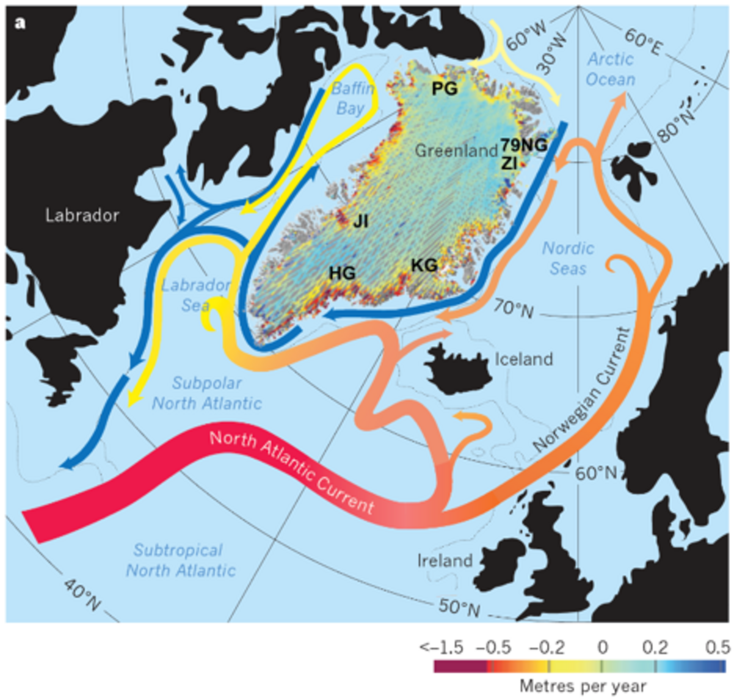
It was found that warm Atlantic waters, which recirculate in the Fram Strait and subsequently flow southwards along the Greenland continental shelf (Fig. 1), were carried across the shelf break by a boundary current, through a trough system, towards the 79NG. The warm water transported towards the inner shelf is referred to as Atlantic Intermediate Water (AIW). Near the glacier front of both 79NG and ZI, the inflow of AIW into the glacier cavity is hydraulically controlled. Local bathymetry in the form of a sill controls the supply of warm AIW from the continental shelf into the cavity where it drives melting at the ice base.
A2Green proposes to extend the focus from the pathways of Atlantic water towards, and drivers of melting at, the 79NG to the entire East Greenland continental shelf, between 81⁰ N and Scoresby Sound at 69⁰ N (Fig. 1). The presence of AIW has been observed both on the continental shelf and in numerous fjords where marine-terminating glaciers are found. As the physical properties of the AIW (temperature, density and thickness of the layer of AIW) are suspected to govern the intensity of ocean-driven melt at the marine-terminating outlet glaciers in Northeast Greenland., it is crucial to understand the circulation and pathways of the AIW onto the shelf and towards the glaciers.
The objectives of the project are:
- Investigate the large scale changes of AIW present on the East Greenland continental shelf, including the drivers of AIW variability between interannual and decadal time scales.
- Determine the role of the continental shelf on the pathways and transport of AIW onto the shelf, and the impact of shelf processes on the AIW properties flowing towards the glaciers.
- Assess the control that bathymetry plays in constraining the amount of AIW entering the fjords and ice sheet cavities.
These goals will be addressed by focusing on two ocean-glacier systems on the East Greenland Shelf. Work on the 79NG at the northern end of the region will be continued, and ocean-glacier interactions will be established within Scoresby Sound, at the southern end of the domain (Fig. 1,2). The Daugaard Jensen Glacier (DGJ) is one of the largest East Greenland glaciers and terminates into Norvestfjord, located within Scoresby Sound. Contrary to the 79NG which terminates directly onto the shelf and is exposed to the open ocean, Scoresby Sound is a large fjord with complex bathymetry where several glaciers are hidden in smaller channels (Fig. 2).
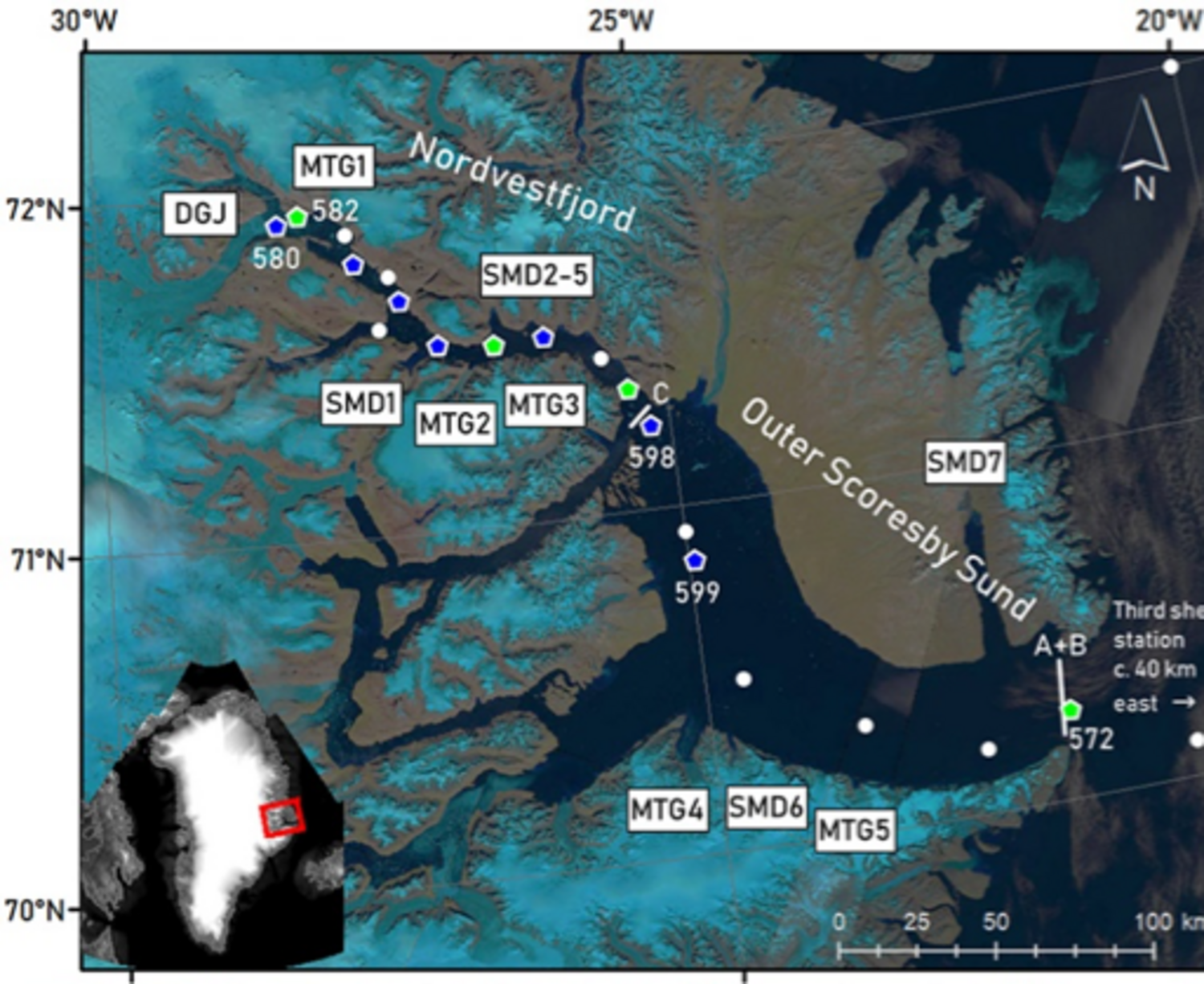
In-situ observations, both historic and recent, of hydrographic and bathymetric data across a variety of spatial and time scales will be used to address the objectives. Long-term observations in the Fram Strait can be combined with data from the outer, mid and inner East Greenland continental shelf, as well as observations from within Scoresby Sound. In addition to the observations, numerical model simulations will be used to focus on process understanding. This combination of approaches will provide a detailed picture of the pathways of warm AIW onto the Northeast Greenland shelf towards the glacial fjords, and the processes which drive this transport and subsequent glacier melting.